Backbone Falls
WHAT IS BACKBONE FALLS
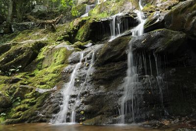
Backbone Falls is a scenic waterfall located within the Backbone Rock Recreation Area in the Cherokee National Forest, just south of Damascus, Virginia near the Virginia–Tennessee border. The falls are formed by Beaverdam Creek as it cascades through a narrow mountain gorge.
The waterfall is easily accessible and is often visited together with Backbone Rock, which features a historic rock tunnel carved through a narrow stone ridge.
Distance from Damascus, Virginia: approximately 15 minutes by car.
ACTIVITIES AT BACKBONE FALLS
Waterfall Viewing
Backbone Falls is a short walk from the parking area and can be viewed from multiple angles.
Photography
The falls, surrounding rock walls, and forest setting make this a popular photography location.
Hiking
Short trails around the recreation area provide easy access to the falls and creek.
Creek Exploration
Beaverdam Creek flows through the area and offers shallow pools and relaxing creekside spots.
Picnicking
Picnic tables and day-use areas are available near the parking area.
Scenic Driving
The drive to Backbone Falls along VA Route 91 is considered scenic and is often combined with other nearby attractions.
SAFETY NOTES
Rocks can be slippery, especially after rain.
Swimming is not recommended.
Stay on established paths.
USEFUL LINKS
Backbone Rock Recreation Area
https://www.fs.usda.gov/recarea/cherokee/recarea/?recid=34838
Cherokee National Forest
https://www.fs.usda.gov/cherokee
Additional area information
https://www.fs.usda.gov/detail/cherokee/recreation/?cid=FSEPRD491221
BEST TIMES TO VISIT
Spring: Strong water flow
Summer: Cool, shaded creek area
Fall: Colorful foliage
Winter: Possible ice formations