South Holston Lake
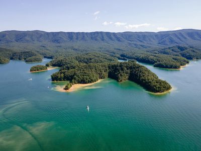
South Holston Lake is a large, deep mountain reservoir located on the Tennessee–Virginia border, just south of Abingdon and Bristol. Surrounded by steep forested ridges and extensive public land managed largely by the Cherokee National Forest, the lake has a scenic, undeveloped feel and is known for clear water and excellent fishing.
Distance from Damascus, Virginia: approximately 40–45 minutes by car.
How the lake was created
South Holston Lake was formed by South Holston Dam, built and operated by the Tennessee Valley Authority (TVA) on the South Fork of the Holston River. The reservoir provides flood control, hydroelectric power, and recreation.
Activities available at South Holston Lake
Boating
Popular for pontoon boats, fishing boats, kayaks, and paddlecraft. Long coves and arms allow for relaxed cruising and exploration.
Kayaking and Canoeing
Protected coves and upper arms offer calm water, especially in the morning.
Stand-Up Paddleboarding
Best on low-wind mornings near recreation areas and coves.
Swimming
Cool, clear water with designated swimming areas near campgrounds and day-use sites.
Fishing
Well known for:
- Smallmouth bass
- Largemouth bass
- Spotted bass
- Walleye
The South Holston River below the dam is also a nationally recognized trout fishery.
Camping and Picnicking
Multiple campgrounds and picnic areas provide shoreline access and scenic views.
Scenic Viewing and Photography
Steep ridges rising from the water create dramatic views. Sunrises, sunsets, and fall foliage are especially popular.
Marinas at South Holston Lake
South Holston Marina
https://southholstonmarina.com
Blue Hole Marina
https://blueholemarina.com
Campgrounds at South Holston Lake
South Holston Dam Campground (Cherokee National Forest)
https://www.fs.usda.gov/recarea/cherokee/recarea/?recid=34830
Osceola Island Campground (Cherokee National Forest)
https://www.fs.usda.gov/recarea/cherokee/recarea/?recid=34832
Jacob Creek Campground (Virginia side)
https://www.fs.usda.gov/recarea/cherokee/recarea/?recid=34822
Best times to visit
- Spring: Fewer crowds, excellent fishing
- Summer: Peak boating, swimming, and camping season
- Fall: Outstanding foliage and cooler temperatures
- Winter: Quiet and scenic, limited facility access
Why people visit South Holston Lake
Visitors appreciate South Holston Lake for its clear water, strong fishing reputation, scenic mountain setting, and peaceful atmosphere compared to more developed lakes.
It pairs well with trips to Abingdon, Bristol, Damascus, and the Virginia Creeper Trail.